
3D modelling is essential for solar projects because it transforms complex engineering challenges into visual, accurate representations that prevent costly construction errors. Modern solar design software uses three-dimensional technology to model terrain, analyse shading, and optimise component placement before installation begins. This comprehensive approach addresses critical questions about implementation, accuracy, benefits, and workflow integration.
What is 3D modelling in solar project development?
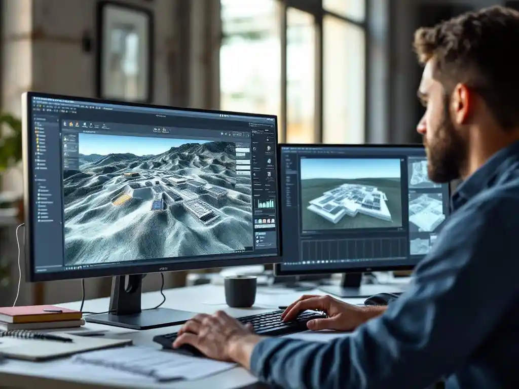
3D modelling in solar project development creates comprehensive three-dimensional representations of photovoltaic installations that include terrain analysis, component placement, and environmental factors. This technology replaces traditional 2D CAD drawings with detailed visualisations that show how solar arrays interact with landscapes, structures, and surrounding obstacles.
The transition from 2D to 3D represents a fundamental shift in solar engineering methodology. Traditional flat drawings often miss critical spatial relationships that become obvious in three-dimensional space. Modern solar design software incorporates terrain elevation data, building structures, and environmental features to create accurate project models.
Advanced 3D modelling systems integrate multiple data layers simultaneously. Terrain topology, shading analysis, cable routing paths, and mounting system requirements all combine within a single three-dimensional environment. This comprehensive approach enables engineers to visualise complex interactions between system components and site conditions that would be impossible to represent accurately in traditional 2D drawings.
The technology particularly excels in utility-scale installations where terrain variations, access roads, and electrical infrastructure create complex spatial challenges. Engineers can model cut-and-fill requirements, optimise panel arrangements for maximum energy yield, and plan construction sequences within the three-dimensional environment.
How does 3D modelling reduce errors and improve accuracy in solar design?
3D modelling reduces errors by enabling engineers to identify potential conflicts and issues before construction begins. Three-dimensional visualisation reveals clash-detection problems, shading conflicts, terrain challenges, and component interference that traditional 2D planning approaches often miss completely.
Clash detection represents one of the most valuable error-prevention capabilities. When electrical conduits, mounting structures, and access pathways are modelled in three dimensions, conflicts become immediately apparent. Engineers can adjust designs to eliminate these issues during the planning phase rather than discovering expensive problems during construction.
Shading analysis becomes significantly more accurate with 3D terrain modelling. Hills, valleys, existing structures, and vegetation create complex shadow patterns that change throughout the day and across seasons. Three-dimensional models calculate these interactions precisely, enabling optimal panel placement and accurate energy-yield predictions.
Automated stringing calculations benefit enormously from 3D spatial awareness. Cable routing, combiner box placement, and inverter positioning can be optimised based on actual terrain conditions and accessibility requirements. This precision reduces material waste and ensures construction teams receive accurate documentation.
Integration with PVsyst and other performance simulation tools ensures that 3D models translate directly into accurate energy production forecasts. This connection between spatial design and performance analysis eliminates discrepancies that often occur when different software tools use incompatible assumptions about site conditions.
What are the key benefits of 3D modelling for utility-scale solar projects?
3D modelling delivers substantial benefits for utility-scale solar projects through improved stakeholder communication, enhanced project visualisation for investors and permitting authorities, better engineering team collaboration, and more accurate material calculations. Large-scale installations require coordination between multiple parties who benefit from clear visual understanding.
Investor presentations become significantly more compelling when supported by realistic 3D visualisations. Rather than interpreting technical drawings, stakeholders can see exactly how the completed installation will appear within the landscape. This visual clarity accelerates approval processes and builds confidence in project feasibility.
Permitting authorities increasingly expect detailed environmental impact assessments that 3D models support effectively. Visual impact studies, drainage analysis, and vegetation preservation planning all benefit from comprehensive three-dimensional site representation. These detailed submissions often expedite regulatory approval processes.
Engineering team collaboration improves dramatically when all disciplines work within shared 3D environments. Civil engineers designing access roads, electrical engineers planning cable routes, and structural engineers specifying mounting systems can coordinate their efforts within unified project models.
Bill-of-materials generation becomes significantly more accurate when based on precise 3D measurements. Cable lengths, mounting hardware quantities, and grading requirements can be calculated directly from the three-dimensional model, reducing procurement errors and cost overruns that plague projects based on estimated quantities.
Construction documentation benefits from 3D-generated drawings that maintain consistency across all project phases. Single-line diagrams, construction details, and installation sequences all derive from the same three-dimensional source, eliminating discrepancies between different drawing sets.
How does 3D modelling integrate with existing solar design workflows?
3D modelling integrates seamlessly with existing solar design workflows through CAD-native platforms that work within established AutoCAD environments. Modern tools maintain compatibility with industry-standard software like PVsyst while adding dimensional accuracy to familiar engineering processes without disrupting proven team workflows.
CAD integration represents the most critical workflow consideration for engineering teams. Rather than requiring completely new software platforms, advanced 3D modelling operates as plugins within existing AutoCAD or BricsCAD environments. This approach preserves established drawing standards, layer conventions, and collaboration protocols that teams have developed over years.
The two-phase design process accommodates both pre-sales feasibility studies and detailed engineering requirements. Initial 3D layouts can be created quickly for project development, then seamlessly transferred to full CAD environments for construction documentation. This workflow eliminates the traditional disconnect between sales layouts and engineering reality.
PVsyst compatibility ensures that 3D models translate directly into performance simulations without data conversion issues. Terrain models, shading objects, and panel arrangements export cleanly to maintain accuracy throughout the analysis process. This integration eliminates manual data entry that introduces errors and consumes engineering time.
Collaboration features enable multiple engineers to work simultaneously within shared 3D project environments. Design changes propagate automatically across all related drawings and calculations, maintaining consistency while supporting parallel work streams that accelerate project delivery schedules.
Enterprise-level capabilities scale effectively from small commercial installations to utility-scale projects exceeding 100 MW of capacity. Teams can standardise unified 3D workflows that handle diverse project types without requiring different software tools or processes for different installation scales.
3D modelling transforms solar project development from reactive problem-solving to proactive design optimisation. The visual clarity, error prevention, and workflow integration capabilities address fundamental challenges that have historically plagued solar engineering teams. As project complexity continues to increase with utility-scale installations and challenging terrain requirements, three-dimensional design tools become essential for maintaining accuracy while meeting aggressive delivery schedules. For more information about advanced solar design solutions or to discuss your specific project requirements, contact our team for expert guidance.
Frequently Asked Questions
What hardware and software requirements are needed to run 3D solar modelling software effectively?
Most 3D solar modelling software requires a modern computer with at least 16GB RAM, a dedicated graphics card (NVIDIA GTX 1060 or equivalent), and AutoCAD or BricsCAD compatibility. Cloud-based solutions can reduce hardware requirements, but local processing power significantly improves performance when working with large utility-scale projects and complex terrain data.
How long does it typically take to create a 3D model for a utility-scale solar project?
Initial 3D layouts for feasibility studies can be completed in 2-4 hours for experienced users, while detailed construction-ready models typically require 1-2 weeks depending on project complexity and terrain challenges. The time investment pays dividends through reduced construction errors and faster approval processes.
Can 3D models be updated easily when project requirements change during development?
Yes, modern 3D solar modelling platforms feature parametric design capabilities that automatically update related components when changes are made. For example, adjusting panel spacing automatically recalculates cable lengths, mounting quantities, and performance metrics throughout the entire project model, maintaining accuracy across all documentation.
What are the most common mistakes teams make when transitioning from 2D to 3D solar design workflows?
The biggest mistakes include trying to replicate exact 2D processes in 3D environments and insufficient team training on new tools. Successful transitions require embracing 3D-native design approaches, establishing new quality control procedures, and ensuring all team members receive adequate software training before project deadlines.
How accurate are the material quantity calculations generated from 3D models compared to traditional estimation methods?
3D-generated material calculations typically achieve 95-98% accuracy compared to 80-85% accuracy from traditional 2D estimation methods. This improved precision reduces procurement costs, minimizes material waste, and eliminates expensive change orders that commonly occur when field conditions don’t match 2D assumptions.
What specific file formats and data sources are needed to import terrain and site information into 3D modelling software?
Most 3D solar modelling platforms accept standard surveying formats including DWG files, point clouds (LAS/LAZ), and digital elevation models (DEM/DTM). Drone survey data, LiDAR scans, and CAD site plans can typically be imported directly, though data quality and resolution significantly impact model accuracy and processing time.
How does 3D modelling handle complex terrain features like steep slopes, wetlands, or existing structures?
Advanced 3D modelling software includes terrain analysis tools that automatically identify unsuitable areas based on slope thresholds, setback requirements, and environmental constraints. These features enable automatic panel placement optimization while respecting site limitations, significantly reducing manual design iteration time for challenging sites.
Related Articles
Source link