
In a new weekly update for pv magazine, Solcast, a DNV company, reports that a low-pressure system over central North America in May suppressed solar irradiance on the East Coast while supporting moderate gains in the West and Midwest.
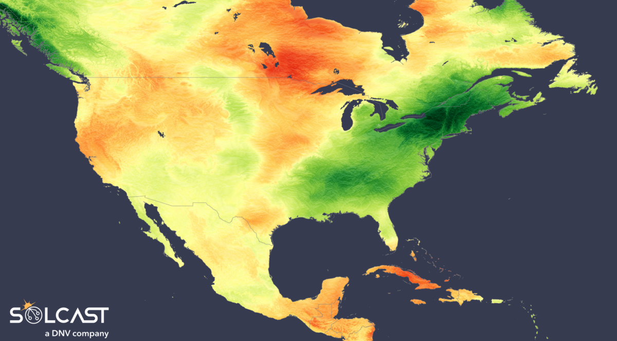
A low-pressure system locked in over central North America shaped May’s solar climate across the continent, drawing cloud and rain over the East while leaving the West under the influence of stabilizing high pressure. According to analysis using the Solcast API, this division suppressed irradiance on the East Coast and supported moderate gains in the West and Midwest, setting up a geographically split solar performance profile.

Throughout May, a persistent low-pressure trough anchored over Canada and the central U.S. funneled storm systems across the eastern seaboard. As a result, solar irradiance plummeted across key regions. From New York to Maine, irradiance was up to 30% below the long-term average for this time of year. Quebec and large swathes of the Southern U.S. also recorded deficits of around 20%. The impact of these conditions was compounded by intense rainfall; in mid-May, a particularly slow-moving storm system led to flash flooding and regional alerts, further disrupting solar potential.
In contrast, the western half of the continent was under the influence of a dominant high-pressure system that brought cool and dry conditions. These stable atmospheric conditions helped maintain slightly above-average irradiance levels across much of the U.S. West and most of Canada. This continuation of a March-established pattern brought consistency in solar availability, although temperatures remained below normal and drought persisted, particularly in the Rocky Mountains.

The Midwest emerged as May’s standout region for solar conditions. While convective storm activity delivered much-needed rainfall that eased some drought concerns, skies remained clear enough to support strong irradiance. Most of the region saw irradiance levels around 10% above average, with peak values reaching up to 30% above normal from Minnesota to central Canada. However, this same dry heat led to significant wildfire activity in Manitoba, with smoke tracked as far as Europe, as previously reported.
Further south, high pressure also shaped Mexico’s May weather, diverting Pacific moisture offshore and preventing significant rainfall. The result was a hotter-than-average and drier month, especially in southern regions. Solar irradiance responded accordingly, with values above average in the south and near-normal elsewhere across the country.
Solcast produces these figures by tracking clouds and aerosols at 1-2km resolution globally, using satellite data and proprietary AI/ML algorithms. This data is used to drive irradiance models, enabling Solcast to calculate irradiance at high resolution, with typical bias of less than 2%, and also cloud-tracking forecasts. This data is used by more than 350 companies managing over 300 GW of solar assets globally.
The views and opinions expressed in this article are the author’s own, and do not necessarily reflect those held by pv magazine.
This content is protected by copyright and may not be reused. If you want to cooperate with us and would like to reuse some of our content, please contact: editors@pv-magazine.com.
Popular content

Source link